By Justin Wier
Youngstown City Council has been struggling with redistricting over the last two years. At a special meeting held on Aug. 20, they finally agreed on maps after an arduous two-year process fraught with disputes, but the maps aren’t perfect.
Thomas Finnerty, director of Youngstown State University’s Center for Urban Studies, was involved in the process early on, but maps he drew had been rejected by council.
“There were some council people who wanted to be in the ward they were in no matter what, despite how much population their ward had lost. They didn’t want to change,” Finnerty said.
Council subsequently obtained new maps from the Mahoning County Board of Elections. The Board of Elections provided the maps free of charge.
Finnerty said rules were disregarded in the new maps in order to keep people in their wards.
“That’s kind of the definition of gerrymandering: drawing lines to keep people or groups within a ward or any political subdivision and not have the compact wards,” he said.
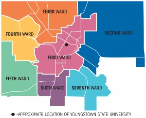
The Youngstown city charter states that, “all wards shall be composed of contiguous and compact territory, as nearly equal in population as possible, and bounded by natural boundaries or street lines.”
Finnerty said the first ward, in which YSU resides, does not meet that standard.
“[The districts are] not compact. If you look at the new maps of the first ward, you’ll see that in the east there’s a thumb-like appendage that goes up, and in the upper-right-hand corner of that appendage is the current councilperson,” Finnerty said. “So that was drawn specifically to keep that person in the first ward.”
Paul Drennen, who represents the fifth ward, agreed with Finnerty’s position.
“If you look at the maps, it’s pretty obvious that some things were moved around to keep certain people happy,” Drennen said.
Drennen said he was happy with the maps Finnerty provided and that getting a second set of maps from the Board of Elections set the redistricting process back a year.
“I don’t think council should have had any say in where boundaries were drawn,” Drennen said.
Annie Gilliam, who represents the first ward, didn’t think it was a big deal.
“They can call it gerrymandering if they want to, but my ward didn’t change a whole lot,” Gillam said.
She said that when council decided not to count inhabitants of a private prison on the city’s east side, the second ward had to be extended to account for population. This required them to move the boundary over slightly to keep her in the first ward where she would like to keep working.
The decision not to count prisoners at the private Northeast Ohio Correction Center prison was reached after concerns were raised by a group called the Prison Policy Initiative. The group considers counting prisoners when redistricting a form of gerrymandering, as they are incapable of voting and do not require representation in Youngstown government.
Mike Ray, who represents the fourth ward, said compromises were necessary to agree upon districts.
“We tried to work out the best solution, an amicable solution, with the body that I work with,” Ray said.
The population of the new wards ranges from 8,949 in the third ward to 9,534 in the fourth
ward, which is a vast improvement upon the current maps that range from 7,227 to 12,130 according to the most recent US census data.
Ray said in his opinion there was nothing wrong with the maps provided by YSU.
“I would’ve went along just with his recommendations,” Ray said. “I respect his work, and think he provided us with unbiased, professionally done, districts.”
Martin Hume, the city’s law director, said he did not play a personal role in the creation of the maps, but did not believe they were in violation of the law.
“The map that was ultimately approved met all the constitutional and statutory requirements for redistricting,” he said.
Comments are closed.